Jūjō Station (Kintetsu)
Jūjō Station (十条駅, Jūjō-eki) is a train station on Kintetsu Railway's Kyoto Line in Minami-ku, Kyoto, Japan. It has the station number "B03".
Stations between Kyoto and Takeda | |||||||||||||||||||||||||||||||||||||||||||||||||||||||||||||||||||||||||||||
|---|---|---|---|---|---|---|---|---|---|---|---|---|---|---|---|---|---|---|---|---|---|---|---|---|---|---|---|---|---|---|---|---|---|---|---|---|---|---|---|---|---|---|---|---|---|---|---|---|---|---|---|---|---|---|---|---|---|---|---|---|---|---|---|---|---|---|---|---|---|---|---|---|---|---|---|---|---|
| |||||||||||||||||||||||||||||||||||||||||||||||||||||||||||||||||||||||||||||
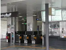
Ticket gate
Jūjō Station 十条駅 | |
|---|---|
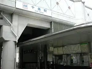 Jūjō Station entrance in September 2006 | |
| General information | |
| Location | Minami, Kyoto Kyoto Prefecture Japan |
| Coordinates | 34°58′26.39″N 135°45′8.81″E |
| Operated by | Kintetsu Railway |
| Line(s) | Kyoto Line |
| Other information | |
| Station code | B03 |
| Website | Official website |
| History | |
| Opened | 1928 |
| Passengers | |
| FY2015[1] | 2.1 |
| Location | |
 Jūjō Station Location within Japan | |
Layout
Jūjō Station has an elevated island platform serving two tracks.[2]
Platforms
| 1 | ■ Kyoto Line | for Tambabashi, Shin-Tanabe and Yamato-Saidaiji |
| 2 | ■ Kyoto Line | for Kyoto |
History
- 1928 - The station opens as a station of Nara Electric Railroad
- 1963 - Naraden merges and the station becomes part of Kintetsu
- 1999 - The station is elevated
- 2007 - Introduction of PiTaPa smart card
Adjacent stations
| « | Service | » | ||
|---|---|---|---|---|
| Kyoto Line (Kintetsu) | ||||
| Tōji | Local | Kamitobaguchi | ||
| Express: Does not stop at this station | ||||
| Semi-Express: Does not stop at this station | ||||
Surrounding area
- Jujo-dori
- Minami Ward Office
- Nintendo Global Headquarters
- SG Holdings Co., Ltd., Sagawa Express Co., Ltd.
See also
References
- 第8章 都市施設 [Chapter 8: Urban facilities]. 京都市統計書 [Statistics of Kyoto City] (in Japanese). City of Kyoto.
- "Station Map". Arukumachi KYOTO Route Planner. City of Kyoto. Retrieved 25 December 2017.
This article is issued from Wikipedia. The text is licensed under Creative Commons - Attribution - Sharealike. Additional terms may apply for the media files.